OpenFront.io contains many interesting and diverse maps which creates a different playing style for each individual map. Some maps are more built for slow expansion, some for quick expansion, some for trade and some for quicker or slower games. A game of Openfront.io is complete when 80% or more of the map has been conquered by one player.
List of Maps
Continental Maps
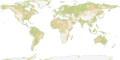
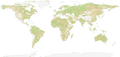
World
Map of the World (sometimes referred to as the globe or Earth map) is a map that shows all of the 7 major continents of the world as well as all 5 major oceans of the world. This also included islands such as the Caribbean islands, the British isles, Iceland, New Zealand, Madagascar, Japan and others. The map's terrain is comprised of an even amount of flat, hilly and mountainous terrain that is quite evenly spread through the map. However, Asia tends to be more mountainous, Africa tends to be more hilly and South America tends to be more flat. However, it should be noted that most of the map of water and with the Panama and Suez canals being a thing, this results in this being one of the best maps for trade and warships.
Giant World Map
A giant map of the World. The map's terrain is comprised of an even amount of flat, hilly and mountainous terrain that is quite evenly spread through the map. However, Asia tends to be more mountainous, Africa tends to be more hilly and South America tends to be more flat. However, it should be noted that most of the map is made of water and with the Panama and Suez canals being a thing, this results in this being one of the best maps for trade and warships.
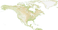
North America
Map of Northern and Central America and Greenland. Mostly hilly and mountainous terrain with some plains mostly near oceans and in the northern and eastern parts of the map. There are a lot of water and rivers.
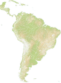
South America
Map of South America, Central America, Florida, and the Caribbean. Mostly flat and mountainous, with some hills mostly in Brazil. Decent amount of water and has the Panama canal, in addition to rivers, making the map good for trade.
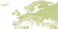
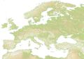
Europe
Map consisting of all continental Europe, as well as nearby islands such as: Great Britain, Ireland, Iceland, Corsica, Sardinia and more. It also shows parts of north Africa and a small part of west Asia. The map's Terrain is mostly flat in the eastern and central regions of the map. However, Scandinavia and the Alps are quite mountainous regions, with areas such as Türkiye and Spain being quite hilly and mountainous. It doesn't include Iceland because the map is a bit stretched compared to the old one. However, it should be noted that while nearly all of the map (except the western side) is land, but due to the Mediterranean Sea and Baltic Sea, and rivers, it is quite a great map for ports.
Europe Classic
This map is a duplicate of the older Europe map without rivers. It is not stretched out like the other maps in the game as well. This map has been added because some players’ devices don’t have enough resources to play the new map, and also because the new map excludes Iceland.
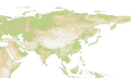
Asia
Map of all of continental Asia, as well as it's nearby islands such as, Japan, Indonesia, the Philippines and Sri Lanka. It also shows parts of east Africa as well as eastern Europe. The map's terrain is quite flat in the north, but in the central regions of the map (such as Tibet/west China and Kazakhstan) there are mountains that are difficult to invade through. However, most of the western side of the map is hilly with a few sparse mountains. Areas other than the north that are also flat are: Indonesia, India, east China and south east Asia. However, it should be noted that most of the map is land, but due to long coastlines and islands, building ports is a great strategy.
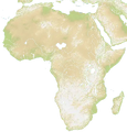
Africa
Map of the African continent with parts of the Italian peninsula, Middle East, and Mediterranean. Terrain is very hilly and mountainous, making spread slow. Africa also has long rivers allowing for trade farther inland via a port.
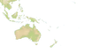
Oceania
Map of Oceania and part of South East Asia. This map is mostly water. Mostly plains and hills with some mountains mainly in the northwest. the east of the map is mostly ocean but there are some small islands which makes it good for trade via ports.
Regional Maps
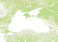
Black Sea
Map of areas surrounding the Black Sea. Mountains everywhere with most of the plains in the northwest and southeast. Center of the map is dominated by water and there are several rivers going across the map. It has the island of Crimea, but most of the map is land. So, it is somewhat harder to attack in the map outside of Crimea. Most of the map is mountain: the flattest part is in the Southern District area of Russia.
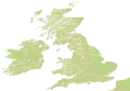
Britannia
Map of the British Isles (Great Britain and Ireland) with a segment of northern France (the Pas-de-Calais).
This map also features historic British kingdoms and lordships (making it the one with the coolest flags!).
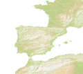
Gateway to the Atlantic
Map of Spain, France, Gibraltar, and Northwest Africa. It has lots of rivers. The nations there include French and Spanish provinces, as well as ones with names such as "Baguettes", "An anti pope", “Wine”, and “Sardines,” referencing French cuisine and history.
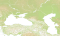
Between Two Seas
Map of the mountainous region between and around the Caspian sea and the Black Sea.
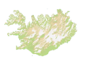
Iceland
Map of the country Iceland. It's mountainous and it has a coastline riddled with fjords and inlets. That makes it not only suitable for land attacks but also for trade.
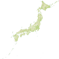
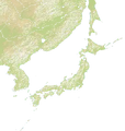
East Asia
This is a map with a large amounts of water and two large landmasses: Kyushu and the Korean Peninsula. Previously named Japan and Neighbors.
MENA
Map of Middle East and North Africa, with some parts of Southern Europe visible. Mostly hilly terrain with most of the mountains present in the northern part of the map. There are some water and rivers.
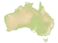
Australia
Map of the country Australia. It's especially suitable for land attacks, as the map is one big island and one smaller island named Tasmania.
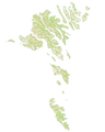
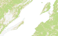
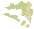
Faroe Islands
Map of the Faroe Islands, a real life island cluster located in the north Atlantic sea, between Iceland and Great Britain. It is currently under the Kingdom of Denmark. The map itself presents a lot of waterways and it is a good map for naval invasions and trading via ports.
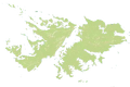
Falkland Islands
Map of the Falkland Islands located outside of Argentina.
It consists of two main islands, surrounded by water on all sides. There are plenty of tiny islands scattered around the main islands.
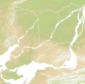
Baikal
Map of Lake Baikal in Siberia, Russia.
It features two sides of the lake, with a large body of water between. In the teams mode this map can tend to become a slow fight fought mostly with nukes as the shore can be well protected with warships.
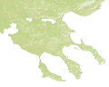
Halkidiki
A map based on where Greece meets the Aegean Sea in the north.
It features three fingers of land, with plenty of water around it.
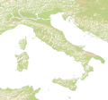
Italia
Map of Italy, Sicily, Sardinia, Parts of Balkans, and Parts of the Iberian peninsula. This is great for land attacks, since mostly is just on one land. But when on islands, warships are great for attacking.
Yenisei
A mess of rivers, land, and islands.
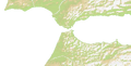
Strait of Gibraltar
Map of the Strait of Gibraltar.
Two pieces of land separated by the naturally occurring Strait of Gibraltar.
Other Maps
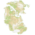
Pangaea
Map of the old continent Pangaea, which already broke apart in real life. It has a few rivers here and there. This map is optimal for land attacks, as there is only one continent, and it is easy to attack other parts of it.
Mars
A map of what Mars might've looked like if it had water on its surface.
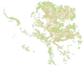
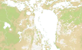
Deglaciated Antarctica
This map consists of Antarctica without ice. This leads to the landmass becoming a huge archipelago as the ice no longer connects the landmasses together, making it the map with the most island in the entire game.
Unused Maps
This section is dedicated for maps that have previously been available, but no longer are.
It could be related to tournaments, events, or maps that are retired.
Known World
This is a map that has been taken out from the available list of maps to play on. It was previously listed under "Other Maps".
It contained two bodies of land both with surrounding water, based on the book series A Song of Ice and Fire by George R.R. Martin that is also the inspiration for Game of Thrones.
Maps and Images
The height maps are terrain maps. These maps show water as grey-white. The colors are different depending on the terrain, with green for plains, Khaki or Tan for highlands and desert, and white for snow, ice, and mountains. The images can update to remove smaller blue things and add green, white, or Khaki or tan things that got erased by the white.
-
 World height map
 -
 Deglaciated Antarctica height map
 -
 Europe Classic height map
 -
 South America height map
 -
 Pangaea height map
 -
 Oceania height map
 -
 North America height map
 -
 MENA height map
 -
 Mars height map
 -
 Japan height map
 -
 Iceland height map
 -
 Gateway to the Atlantic height map
 -
 Faroe Islands height map
 -
 Europe height map
 -
 Australia height map
 -
 Africa height map
 -
 Britannia height map
 -
 Black Sea height map
 -
 Between Two Seas height map
 -
 Asia height map
 -
 Italia height map
 -
 Giant World Map height map
 -
 Falkland Islands height map
 -
 Baikal height map
 -
 Halkidiki height map
 -
 Strait of Gibraltar height map
 -
 Montreal height map
 -
 Pluto height map
 -
 Achiran height map
 -
 East Asia height map
Summary
- Reminder to Add more maps to this page when the update adds any!
- Reminder to add height maps for all new maps (download them by clicking a map’s preview on the singleplayer menu)
See also
- Height Map
- Map Making Guide