Not to be confused with Europe Classic
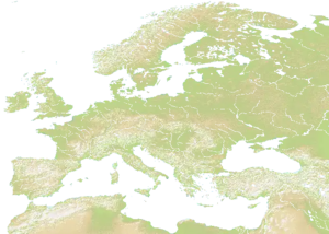
Europe is a map consisting of all continental Europe, as well as nearby islands such as: Great Britain, Ireland, Iceland, Corsica, Sardinia and more.
It also shows parts of north Africa and a small part of west Asia.
The map's Terrain is mostly flat in the eastern and central regions of the map. However, Scandinavia and the Alps are quite mountainous regions, with areas such as Türkiye and Spain being quite hilly and mountainous.
Due to the Mediterranean Sea and Baltic Sea, and rivers, it is a great map for ports.
Technical
The size of the map is 2300 x 1647.[1]
Due to this map being stretched, it meant that Iceland no longer fit in on the map.
The original version of this map is named Europe Classic.